A Guide to Unmissable North York Moors Walks and Hikes
Explore stunning North York Moors walks and trails in this diverse and scenic national park. Covering 554 square miles, the North York Moors is characterised by its dramatic coastal cliffs to the east, the steep slopes of the Cleveland Hills to the west and north, and the picturesque Vale of Pickering to the south. Established as a national park in 1952, it features a variety of landscapes, from expansive heather moorland and dense forests to unique landforms shaped by the last ice age. Visit the official website to read more about this amazing place.
Below, I highlight three of my favourite North York Moors walks, each offering a unique adventure. Remember, these are just a few of the many trails available in this beautiful region. For a comprehensive list, continue scrolling down the page.
North York Moors Walks: My Top Three
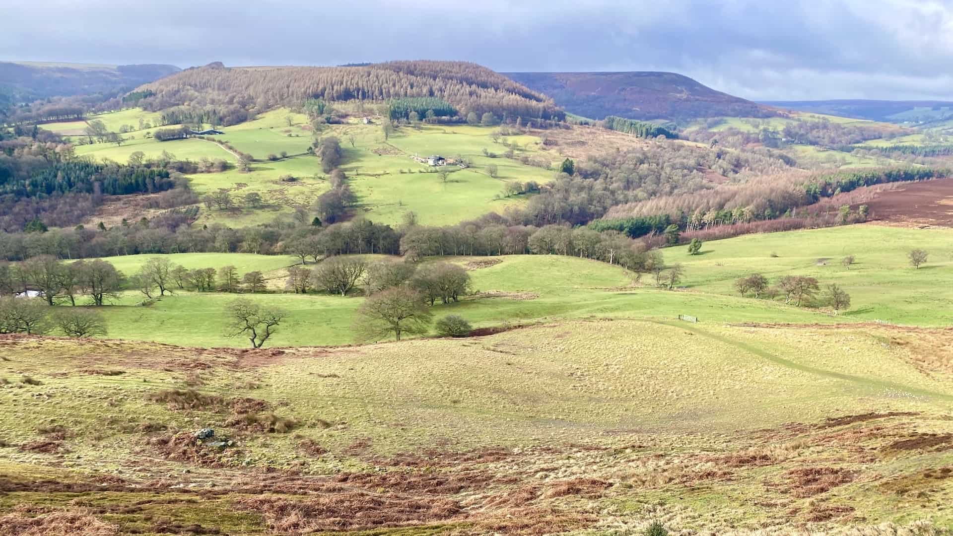
One of my favourite North York Moors walks is the Hole of Horcum circular. This trail begins at Saltergate and takes you through the breathtaking scenery of the Hole of Horcum, also known as the ‘Devil’s Punchbowl.’ The route offers stunning views of this natural amphitheatre and provides a fascinating insight into the area’s geological history. The trek continues along the Tabular Hills Walk, featuring a mix of heather moorland and countryside paths, before passing through the picturesque village of Levisham and returning via the lush valley of Horcum Slack. The diverse terrain and spectacular vistas make this walk a must-see for any visitor.
Another top choice from my collection of North York Moors walks is the Grosmont walk, perfect for history enthusiasts and walkers alike. Starting in the quaint village of Grosmont, this walk meanders through a variety of landscapes, including serene woodlands, open moorland, and disused, historic railway lines. The trail starts with a stroll through Doctors Wood, then ascends to Dale End and crosses open countryside. A key highlight of this walk is the visit to the charming Goathland Railway Station, a notable destination for fans of the North Yorkshire Moors Railway. The route also includes a pause at the Mallyan Spout waterfall, adding a refreshing natural element to the journey. The Grosmont walk combines historical intrigue with natural beauty, making it a delightful outing.
The Rosedale Railway walk is my third top pick of North York Moors walks, offering a fascinating journey through the area’s industrial past. This walk starts at the Lion Inn on Blakey Ridge and follows the historic Rosedale Railway trackbed. The path provides a gentle introduction along the valley’s western edge and passes significant historical sites, such as the impressive Iron Kilns at Rosedale East Mines. These remnants of the once-thriving ironstone industry stand as silent monuments to the past. The walk continues through picturesque farmland and up challenging inclines, offering stunning panoramic views of the surrounding countryside. The combination of historical landmarks and scenic vistas makes this walk a unique excursion.
These three North York Moors walks showcase just a fraction of the incredible adventures available in this beautiful region. Whether you’re seeking challenging hikes, historical discovery, or peaceful nature walks, the North York Moors has a trail to suit every preference. For more detailed descriptions and a wider selection of routes, please explore the full list below.
Stunning Walks in the North York Moors
Baysdale Abbey: Walk and Explore the History of North York Moors
12 miles
Blakey Ridge Walk: Experience Rosedale’s Countryside and Views
8 miles
Castleton Walk: Trekking Ancient Pathways in the North York Moors
12 miles
Dalby Forest Walk: Thornton-le-Dale to Dalby Forest Visitor Centre
9 miles
Danby Beacon Walk: Scenic Route From Lealholm to Danby Castle
11 miles
Danby Walk: Exploring the Beauty of the North York Moors on Foot
12 miles
Esk Valley Walk: Two Key Sections, Danby Dale and Westerdale
12 miles
Farndale Daffodils Walk: Church Houses to Low Mill Circular Route
4 miles
Farndale Daffodils: Walk Low Mill to Church Houses, Family Route
4 miles
Farndale Walk: Explore Scenic Trails and the Quaker Burial Ground
9 miles
Goathland Walk: The Perfect Family-Friendly Day Out for All Ages
4 miles
Goathland to Grosmont Walk: A Journey Through Railway History
7 miles
Gormire Lake Walk: A Delightful Trek From Sutton Bank To Boltby
9 miles
Grosmont to Goathland Walk: Scenic Route with Railway Heritage
7 miles
Grosmont Walk: Explore Old Railway Lines and Charming Stations
9 miles
Hawnby Hill: A Delightful Nine-Mile Walk in the North York Moors
9 miles
Helmsley Circular Walk: A Serene Trek Through North York Moors
8 miles
Helmsley to Rievaulx Abbey Walk: A Scenic Family-Friendly Route
7 miles
Helmsley Walk: A Journey Through Peaceful Woodlands and Dales
10 miles
Hole of Horcum Circular Walk: Stunning Views and Moorland Trails
7 miles
Lordstones Walk: Experience Wainstones and Cringle Moor Views
11 miles
Osmotherley Walk: Lady Chapel, Sheepwash, and Stunning Views
7 miles
Rievaulx Abbey Walk: Journey Through Rye Dale and Old Byland
11 miles
Rosedale Abbey Railway Walk: Historic Kilns and Stunning Views
12 miles
Rosedale Abbey Walk: Enjoy Lastingham and the Rosedale Valley
9 miles
Rosedale Railway Walk: Explore Historic Tracks and Superb Views
9 miles
Urra Moor Walk: Exploring Woodland Trails and the Cleveland Way
10 miles
Wainstones Walk: From Chop Gate to the Iconic Rocky Formations
8 miles
About the North York Moors
The North York Moors is an upland area in north-eastern Yorkshire. It boasts one of the largest expanses of heather moorland in the United Kingdom. This area was designated as a National Park in 1952, covering 554 square miles (1435 square kilometres) with a population of 23,380. The North York Moors National Park Authority, based in Helmsley, administers the park.
North York Moors Location and Roads
To the east, the impressive cliffs of the North Sea coast define the area. The northern and western boundaries are marked by the steep scarp slopes of the Cleveland Hills and Hambleton Hills, which edge the Tees lowlands and the Vale of Mowbray, respectively. The south is bordered by the Tabular Hills and the Vale of Pickering.
Several roads cross the North York Moors from north to south. In the east, the A171 connects Whitby and Scarborough. Further inland, the A169 runs between Pickering and Whitby. Centrally, a minor road from the A170 at Keldholme passes through Castleton and joins the A171, which links Whitby and Guisborough. The B1257, the most westerly route, connects Helmsley to Stokesley. The A170 from Thirsk to Scarborough marks the southern boundary of the moors.

North York Moors Physical Geography
The North York Moors feature a moorland plateau dissected by deep dales and valleys, often containing cultivated land or woodland. The largest dale is Eskdale, home to the River Esk, which flows from west to east, emptying into the North Sea at Whitby. The Cleveland Hills rise north of Eskdale. At Eskdale’s western end, the valley splits into three smaller dales: Westerdale (the upper valley of the River Esk), Baysdale, and Commondale. The southern side of Eskdale has several side dales, including Danby Dale, Little Fryup Dale, Great Fryup Dale, Glaisdale, and the Goathland valley. Kildale, west of Commondale, is drained by the River Leven, which flows west to join the River Tees.
On the south side of the moorland, several dales drain into tributaries of the River Derwent. The westernmost dale is Rye Dale, with the Hambleton Hills rising to the west. Bilsdale, a side dale of Rye Dale, is east of Bransdale, Farndale, Rosedale, and Newton Dale, which cut into the moorland. The south-east features the narrow valleys of the upper reaches of the Derwent and its tributaries. About 23% of the North York Moors is covered by woodland, mainly in the south-west and south-east.
North York Moors Geology
The geology of the North York Moors is primarily composed of rocks from the Jurassic period, formed 205 to 142 million years ago. These rocks were laid down in subtropical seas, resulting in a variety of rock types from shales to sandstones and limestones. The Yorkshire coast, from Staithes to Filey, showcases these marine and deltaic deposits.
Lower Jurassic
Shales, clays, thin limestones, and sandstones were deposited in a shallow sea at the beginning of the Jurassic period. These include ironstone layers and alum-bearing rocks.
Middle Jurassic
Gradual uplift led to mudstone and sandstone deposits on a low-lying coastal plain. Calcareous rocks with marine fossils, known as the Ravenscar Group, were occasionally deposited during sea inundations.
Upper Jurassic
The land sank beneath the sea, leading to the deposition of calcareous sandstones and limestones, known as the Corallian rocks, in the Tabular Hills. The Kimmeridge Clay, underlying the Vale of Pickering, is not exposed at the surface.
About 30 million years ago, the land was uplifted and tilted southwards, exposing older rocks in the north, such as the shales and ironstones on the northern scarp of the moors and Cleveland Hills. Sandstones form the high moorland, while the youngest limestone layers create the Tabular Hills. Rivers in the dales have exposed older rocks, such as shales, ironstone, and sandstone, as seen in Rosedale.
During the Quaternary period, glaciers shaped the landscape. The most recent glaciation, the Devensian, ended around 11,000 years ago. The higher parts of the North York Moors were not covered by ice sheets, but glaciers flowed southwards. Meltwater carved deep valleys, such as Newtondale and the Kirkham gorge, and deposited boulder clay, altering the course of the River Derwent.
North York Moors Economy
The economy of the North York Moors relies on agriculture, tourism, and entertainment.
Agriculture
For over a thousand years, agriculture has been the backbone of the local economy. The picturesque rural landscape, which attracts millions of visitors annually, has been shaped and maintained by generations of farmers. According to the 1996 Agricultural Census, 2913 people worked on 1342 farms, with sheep and cattle being the primary sources of income. The right to graze sheep on open moorland is vital for the economic viability of many farms. Despite various environmental schemes to support farmers, the viability of hill farming remains uncertain. Grouse shooting and farming share the use of moorland. In the richer farmland across the southern limestone belt, arable and mixed farming are common, with crops like barley, wheat, oilseed rape, potatoes, and sugar beets. Intensive pig and poultry production also occurs.
Tourism
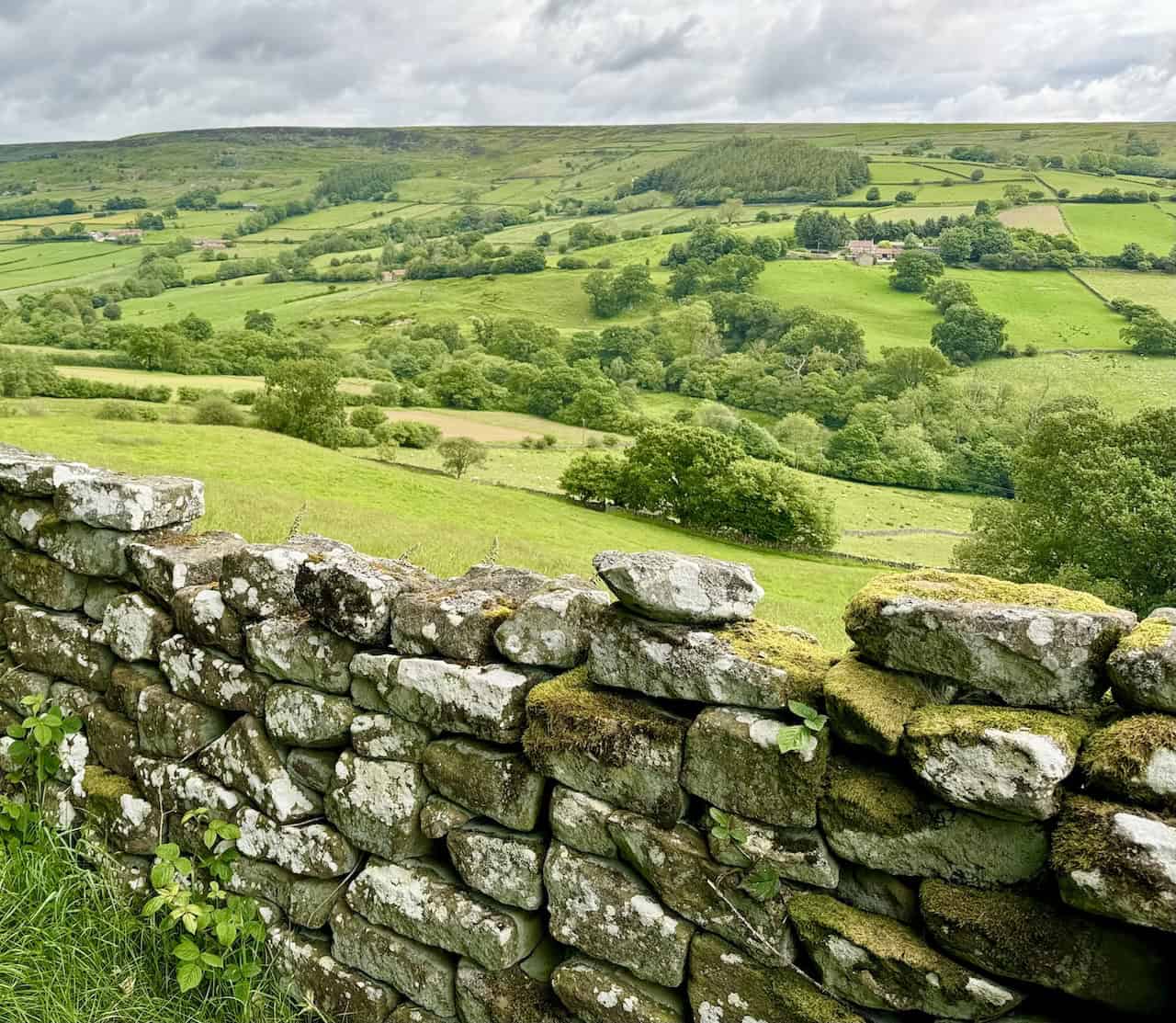
Outdoor pursuits, particularly North York Moors walks, draw many visitors to the area. The National Park has nearly 1400 miles (2300 kilometres) of public rights of way. Open moorland areas are accessible under the Countryside and Rights of Way Act 2000. Popular trails include the Cleveland Way, circling the moors and featuring a coastal section, and the Lyke Wake Walk, crossing the park’s heart. The White Rose Way, a long-distance path from Leeds to Scarborough, also traverses the area.
Cycling, mountain biking, and horse-riding are popular activities, with a circular long-distance bridle route available. Several gliding clubs use the steep escarpments around the park. In late 2020, the National Park was designated an International Dark Sky Reserve, recognised for its low light pollution and excellent conditions for stargazing.
The park has two visitor centres offering tourist information and exhibitions: Sutton Bank and The Moors National Park Centre in Danby.
Entertainment
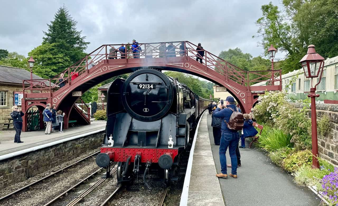
The North York Moors’ timeless landscapes have featured in numerous British television programmes and films. The series Heartbeat and scenes of Hogsmeade Station from the Harry Potter movies were filmed in Goathland. The film version of Downton Abbey shot scenes at the Pickering station of the North Yorkshire Moors Railway. Recent films like The Runaways (2020), The Secret Garden (2020), and Miss Willoughby and the Haunted Bookshop (2020) also featured the park.
Dalby Forest hosts various entertainment events throughout the year, including outdoor concerts. North York Moors walks are a common activity in these settings, with visitors exploring the scenic and historical landscapes.
Amazon’s Top Walking Boots: Four Standout Choices for Men and Women
For walking and hiking, the right boots are essential for both comfort and safety. While Amazon boasts a wide range, certain boots emerge as top-sellers. From those, here are four I personally favour. As an Amazon affiliate, I may earn a small commission from any purchases made through the links provided. This helps support the upkeep of this website. Rest assured, you won’t pay a penny extra, but your purchase will contribute to keeping my site running smoothly. Happy walking!

Berghaus Men’s Hillmaster II Gore-Tex Walking Boots
These fully waterproof leather walking boots feature a Gore-Tex lining, ensuring no water enters whilst allowing feet to breathe and stay cool. Made from full-grain leather, they promise unmatched durability and comfort. The boots come with memory foam tongues and cuffs that mould to your feet for a tailored fit, and the Vibram Hillmaster outsoles offer confidence on challenging terrains.

Salewa Men’s Mountain Trainer Mid Gore-Tex Walking Boots
Made from durable suede and abrasion-resistant textile, these men’s hiking boots are both lightweight and sturdy. The upper material is enhanced by a 360° full rubber sheath. Their dual-layer midsole with Bilight technology ensures ergonomic cushioning and grip, especially on extended hikes. The Vibram Wrapping Thread Combi outsoles allow a natural walking feel, and the Gore-Tex lining provides waterproofing, breathability, and optimal weather protection. Furthermore, the patented Salewa 3F system ensures flexibility, a secure heel grip, and a blister-free fit.

Berghaus Women’s Supalite II Gore-Tex Walking Boots
Specially designed for women, these hiking boots offer waterproofing and breathability, thanks to their Gore-Tex lining. Crafted from full-grain abrasion-resistant leather, they’re durable enough for the toughest hikes. The Supalite soles ensure stability and traction, and the EVA midsoles add comfort for extended walks.

Merrell Women’s Moab 3 Mid Gore-Tex Walking Boots
These hiking boots incorporate a Gore-Tex waterproof membrane, blending breathability with superior waterproof performance. The combination of pigskin leather and mesh on the uppers, along with the suede outer material, ensure durability and style. Enhancements include 100% recycled laces, webbing, and mesh lining. Additionally, bellows tongues, protective toe caps, and Vibram TC5+ rubber soles ensure protection and ease on any terrain.