Enjoy the Beauty of Wensleydale on this Hawes Walk in the Yorkshire Dales
Your Hawes walk starts in the centre of Hawes, a picturesque town in the Yorkshire Dales. Park in Gayle Lane Car Park, located on the western side of the town. Gayle Lane is just off the A684 main road, near Hawes Community Primary School. From the car park, turn left onto Gayle Lane and head south. You’ll pass the Wensleydale Creamery Visitor Centre on your left.
Next, continue along the road into the village of Gayle. When you cross the bridge over Gayle Beck, take the left turn signposted Bainbridge. After passing a few houses, take the public footpath on your right into the fields. Follow the trail uphill, initially heading south-east, then bearing east across the countryside. As you approach the village of Burtersett, the path widens into Shaws Lane.

Before reaching Burtersett, turn right off Shaws Lane and follow the bridleway. This trail ascends south-west towards Yorburgh. The bridleway passes the west side of Yorburgh’s summit. You might want to take a short detour to the summit for stunning views of Wensleydale. Then, continue south on the bridleway until you reach a footpath that leads you to a wide stone track, once a Roman road. Turn left onto this track, called Cam High Road. Follow Cam High Road in a north-east direction for approximately 2¾ miles (4.4 kilometres).
On Cam High Road, after crossing one minor road at Four Lane Ends, continue until you reach another minor road leading to Bainbridge. This point marks the halfway point of your Hawes walk. Follow this minor road straight ahead for about ¾ mile (1.2 kilometres) into Bainbridge. Here, you can explore the village and perhaps stop for lunch at a café or pub. Walk north through the village to the Rose & Crown Hotel, then follow the road signposted Askrigg.

Continue along the road for about ¾ mile (1.2 kilometres) to reach Yore Bridge, which crosses the River Ure. After crossing the bridge, turn left and follow the public footpath diagonally across a field to a farm near the road at Yorescott. Then, turn left and briefly walk along the road before taking a right onto a footpath. Head west across fields until you meet a track leading to a farm at Brockhill Cote.
Follow the track past the farm on your right, then briefly uphill before taking a left onto a footpath. This path leads you west across farmland for 2¾ miles (4.4 kilometres). This section of your Hawes walk is easy to navigate but can be muddy in wet weather. Pass the farms at Shaw Cote and Litherskew to arrive at Sedbusk. Turn left onto Sedbusk Lane, then quickly take the public footpath signposted Haylands Bridge on your right. This path guides you across fields to Brunt Acres Road by the River Ure.
Finally, cross Haylands Bridge and soon after, take the path on your right, guiding you back to Hawes. You’ll reach the A684 main road on the eastern side of the town, allowing you to walk through the delightful town to conclude your Hawes walk. Hawes is a charming town in the Yorkshire Dales, with shops, cafés, restaurants, and pubs—perfect for relaxing after your 12-mile trek.
Hawes Walk: Maps and Tools
Visit either the OS Maps website or the Outdooractive website to view this walking route in greater detail. Both platforms offer a range of features, including the ability to print the route, download it to your device, and export the route as a GPX file. You can also watch a 3D fly-over and share the route on social media.
Hawes Walk: Distance, Duration, Statistics
Distance: 12¼ miles
Distance: 19¾ kilometres
Duration: 5¾ hours
Ascent: 1595 feet
Ascent: 486 metres
Type: Circular walk

Recommended Ordnance Survey Map
The best map to use on this walk is the Ordnance Survey map of the Yorkshire Dales Northern & Central Area, reference OS Explorer OL30, scale 1:25,000. It clearly displays footpaths, rights of way, open access land and vegetation on the ground, making it ideal for walking, running and hiking. The map can be purchased from Amazon in either a standard, paper version or a weatherproof, laminated version, as shown below.
Standard Version
About Hawes
Hawes is a market town and civil parish in North Yorkshire, located within the Yorkshire Dales National Park. It sits at the head of Wensleydale and was historically part of the North Riding of Yorkshire. As of 2011, Hawes had a population of 887. The parish also includes the nearby hamlet of Gayle, a scenic spot you will pass through on your Hawes walk.
Discovering the Rich History of Hawes
The Domesday Book of 1086 makes no mention of a settlement where Hawes now stands. Historically, the area was part of the large ancient parish of Aysgarth in the North Riding of Yorkshire. The first significant mention of Hawes dates back to the 15th century, when the population had grown enough to justify building a chapel of ease. The town was first recorded as having a marketplace in 1307.
The name ‘Hawes’ comes from the Old Norse word ‘hals,’ meaning ‘neck’ or ‘pass between mountains.’ In 1699, King William III granted the town a charter to hold markets, allowing for a weekly Tuesday market and two annual fairs. By 1887, an auction market was established, holding cattle sales fortnightly, along with several annual fairs for cattle, sheep, and cheese.
Hawes became a separate ecclesiastical parish in 1739 and a civil parish in 1866. The Richmond to Lancaster Turnpike was diverted through Hawes in 1795, enhancing its connectivity. The Wensleydale Railway reached Hawes in 1878, although the railway station closed in 1954. The original station site is now part of the Dales Countryside Museum and houses a bike shop and café. You will find the town fascinating as you explore it at the end of your Hawes walk.
Gayle and Hawes once had water-powered mills, such as Gayle Mill, built in 1784. These mills were used for various purposes, including grinding corn, producing textiles, generating electricity, and sawing wood. Gayle Mill adopted new technology in 1789, becoming a mechanised sawmill powered by a double-vortex turbine. It provided electricity to the area until 1948.
Exploring the Geography of Hawes
The parish of Hawes covers large areas of moorland, including Dodd Fell, Snays Fell, Stags Fell, and Widdale Fell. It also includes tributaries of the River Ure, such as Widdale Beck and Gayle Beck, the latter you’ll cross on your Hawes walk. The parish is dotted with abandoned lead mines, quarries, and limekilns, reflecting its industrial past. Aysgill Force waterfalls are a short distance from the town. The highest point in the parish is Great Knoutberry Hill at 2205 feet (672 metres). The parish extends as far north as Hellgill Bridge.
Understanding the Economy of Hawes
Wensleydale Creamery on Your Hawes Walk
The largest company in Hawes is the Wensleydale Creamery, employing 224 staff and attracting 250,000 visitors annually. Although it closed in 1992, the former management team reopened it within six months. The creamery moved to its current location in 2015 and continues to handcraft cheese using traditional recipes dating back to French monks in the 12th century. Wensleydale Creamery has won numerous awards, including Supreme Champion in 2018 for its new Yorkshire Cheddar at The Great Yorkshire Show’s Cheese and Dairy Show.
The creamery’s cheeses have Protected Food Name Status, meaning ‘Yorkshire Wensleydale’ can only be used for cheese made in Wensleydale. A visit to the creamery for refreshments is a highlight of any Hawes walk.
Tourism and Agriculture in Hawes
Hawes is a market town with shops and accommodation for visitors, and tourism is vital to its economy. The local farms raise sheep and cattle and grow meadow grass for hay and silage. Over 40 farms in the area supply the Wensleydale Creamery with milk.
Key Attractions to Visit After Your Hawes Walk
Attractions in Hawes include the Dales Countryside Museum, Hardraw Force waterfall, and the Buttertubs Pass. Hawes has a regular market on Tuesdays, numerous shops, pubs, tearooms, and a youth hostel. The town is also a centre for walking, with the Pennine Way passing through.
Historical Landmark Gayle Mill Near Hawes
Just south of Hawes, Gayle Mill is a Grade II listed building and a scheduled monument. Featured in BBC2’s ‘Restoration’ programme in 2004, the mill underwent significant restoration, costing over £1 million. Though it was open to visitors in 2017, safety and insurance concerns led to its closure in 2018. Fundraising efforts are underway to reopen it.
Hawes Walk: My Photos
This is Gayle Beck flowing through the centre of Gayle village. I’ve seen this scene captured by photographers on many occasions. This picture is an early highlight of my Hawes walk.

At Burtersett Institute in the heart of Burtersett village, I take the opportunity to call in for a cup of coffee. Although it’s slightly further into the village than necessary, I double back to take the path up to Yorburgh.

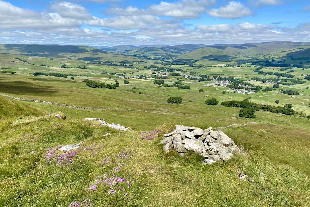
I enjoy wonderful views of Wensleydale as I look down upon Burtersett from the track leading up to Yorburgh.

The summit of Yorburgh, standing at 515 metres (1690 feet), offers superb views of the hills and mountains to the north-west, including Great Shunner Fell, Swarth Fell, and Wild Boar Fell. Since the summit is not directly on the path, I make a quick detour to reach it.
This photograph marks the start of my long trek along Cam High Road to Bainbridge. As you can see, there’s little chance of getting lost on this section of my Hawes walk.

Cam High Road, an old Roman road, is perfectly straight. For the most part, it is covered in loose stones, which makes walking along it tiresome. However, the route is downhill, the views are spectacular, and there are no navigational problems to overcome.

I captured this lovely scene of the River Ure from Yore Bridge, just north of Bainbridge.

Yore Bridge is a charming stone bridge with three arches crossing the River Ure.

I head west across grassy paths and farmland towards Sedbusk on the northern side of the Wensleydale valley.

The hamlet of Sedbusk, about a mile north-east of Hawes, is worth a quick detour to explore. This beautiful little hamlet adds charm to my Hawes walk.
I enjoy a stunning view south from Sedbusk across Wensleydale to Yorburgh while sitting on a stone bench and sipping tea from my flask.

I love this stone-flagged path during the later stages of my Hawes walk. It’s the route from Sedbusk down to Haylands Bridge.

Finally, amazing scenes await at Haylands Bridge, which crosses the River Ure near Hawes.

Amazon’s Top Walking Boots: Four Standout Choices for Men and Women
For walking and hiking, the right boots are essential for both comfort and safety. While Amazon boasts a wide range, certain boots emerge as top-sellers. From those, here are four I personally favour. As an Amazon affiliate, I may earn a small commission from any purchases made through the links provided. This helps support the upkeep of this website. Rest assured, you won’t pay a penny extra, but your purchase will contribute to keeping my site running smoothly. Happy walking!

Berghaus Men’s Hillmaster II Gore-Tex Walking Boots
These fully waterproof leather walking boots feature a Gore-Tex lining, ensuring no water enters whilst allowing feet to breathe and stay cool. Made from full-grain leather, they promise unmatched durability and comfort. The boots come with memory foam tongues and cuffs that mould to your feet for a tailored fit, and the Vibram Hillmaster outsoles offer confidence on challenging terrains.

Salewa Men’s Mountain Trainer Mid Gore-Tex Walking Boots
Made from durable suede and abrasion-resistant textile, these men’s hiking boots are both lightweight and sturdy. The upper material is enhanced by a 360° full rubber sheath. Their dual-layer midsole with Bilight technology ensures ergonomic cushioning and grip, especially on extended hikes. The Vibram Wrapping Thread Combi outsoles allow a natural walking feel, and the Gore-Tex lining provides waterproofing, breathability, and optimal weather protection. Furthermore, the patented Salewa 3F system ensures flexibility, a secure heel grip, and a blister-free fit.

Berghaus Women’s Supalite II Gore-Tex Walking Boots
Specially designed for women, these hiking boots offer waterproofing and breathability, thanks to their Gore-Tex lining. Crafted from full-grain abrasion-resistant leather, they’re durable enough for the toughest hikes. The Supalite soles ensure stability and traction, and the EVA midsoles add comfort for extended walks.

Merrell Women’s Moab 3 Mid Gore-Tex Walking Boots
These hiking boots incorporate a Gore-Tex waterproof membrane, blending breathability with superior waterproof performance. The combination of pigskin leather and mesh on the uppers, along with the suede outer material, ensure durability and style. Enhancements include 100% recycled laces, webbing, and mesh lining. Additionally, bellows tongues, protective toe caps, and Vibram TC5+ rubber soles ensure protection and ease on any terrain.